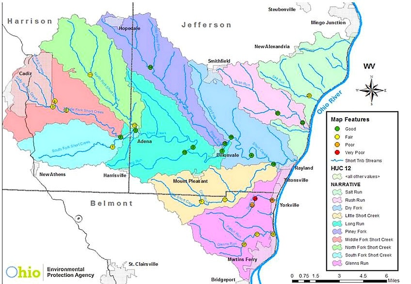
Short Creek
Rivers and streams in Ohio support a variety of uses related to recreation, water supply, and aquatic life.
The Short Creek watershed runs through southern Jefferson, eastern Harrison and northern Belmont counties. Its streams are direct Ohio River tributaries.
Short Creek is 29.4 miles long and has a drainage area of 148 miles squared. Over 30% of the Short Creek watershed has been surface mined and 33% has been underground mined. The study area is 56.8% forest, 26.7% agriculture, 11.6%
developed areas and 5% open water, wetlands and grasslands (Figure 7). Agricultural activities take place in the few areas where there are wide stream valleys and, in many cases, on old strip mine land on ridge tops.
The heaviest development is along the Ohio River in the cities of Martins Ferry, Yorkville and Tiltonsville. The villages of Adena, Cadiz and Dillionvale also are well developed, but on a much smaller scale. Adena and Dillionvale are located in the Short Creek valley while Cadiz is located on a ridge top.
The Ohio Environmental Protection Agency has recently studied the water quality in Short Creek. The resulting biological and water quality reports for Short Creek can be found below: